Things to Do at Lake Mývatn: Nine Stops, Ranked
The things to do at Lake Mývatn are nine sights ringing one basin, and none of them charges an entry fee. What they cost you is time, and that is the thing worth planning. A full ring takes about six hours with the driving, which is exactly what the guided departures from Akureyri run. Below is each stop with what it actually is, how long it needs, how hard the ground is and what to drop first when the day runs short. The Lake Mývatn tour line-up sits on the homepage.
Quick answer
The nine things worth doing at Lake Mývatn are Dimmuborgir, Hverir, Hverfjall, Skútustaðagígar, Grjótagjá, Goðafoss, the Krafla caldera and Víti crater, the Lofthellir ice cave and the geothermal lagoon. All except the cave and the lagoon are free, and the first six sit within 20 km of Reykjahlíð. A full circuit takes six hours including the drive from Akureyri.
Key takeaways
- Free with free parking: Goðafoss, Skútustaðagígar, Dimmuborgir, Hverfjall, Grjótagjá, Hverir, Krafla and Víti
- Paid: the geothermal lagoon from 7,900 ISK, and Lofthellir, which needs a guided trip with equipment
- Longest stop worth booking time for: Dimmuborgir, where the trails run 20 minutes to an hour
- Best single viewpoint: the Hverfjall rim, 20 minutes up from the western car park
- Only closed seasonally: Krafla and Víti under snow into late spring, Lofthellir guided May to October
- You cannot bathe in the lake or in Grjótagjá, so the water part of the day is the lagoon
The Nine Stops
1. Dimmuborgir, the lava city
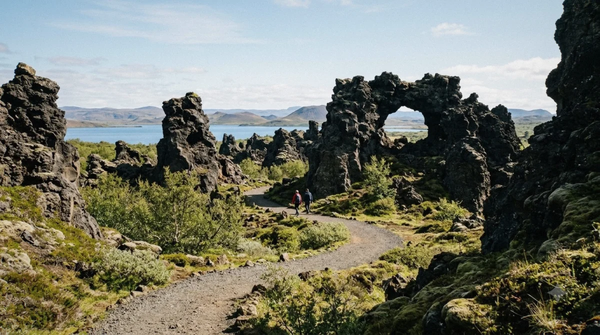
A lava lake that pooled over wet ground, boiled, drained and left the plumbing standing: pillars, arches and hollow chambers spread over a field you walk into rather than look at. Trails are colour marked from a 20 minute circuit to an hour, and the Kirkjan arch at the far end is the one people photograph.
Icelandic children know it as the home of the thirteen Yule Lads, which fills the site with families through December. Ground is packed gravel with roots and steps. There is a café and toilets at the entrance, which makes it the natural lunch stop on a self-driven day.
2. Hverir, the boiling ground
Over the pass east of the lake, the vegetation stops and the ground turns orange. Mud pools thump, vents hiss under pressure, and a short way down the temperature runs past 200°C. The crust looks solid in places where it is not, which is why the marked paths matter more here than anywhere else in the region.
Allow 30 to 40 minutes. The sulphur smell reaches the car park before you do and clings to clothing, so leave the good jacket in the vehicle. Cold air makes the steam stand taller, so this stop is better in winter than in July.
3. Hverfjall, the crater you can walk
A tephra ring roughly 1,000 metres across and 140 metres deep, thrown up in a single explosive eruption about 2,800 years ago. The path from the western car park climbs to the rim in about 20 minutes over loose black gravel, and the full circuit of the rim takes an hour more.
From the top you get the whole basin at once: the lake and its crater islands on one side, the steam of the Krafla system on the other. In wind this is an exposed, unpleasant climb. On a still day it is the best 20 minutes at Mývatn.
4. Skútustaðagígar, the craters that are not craters
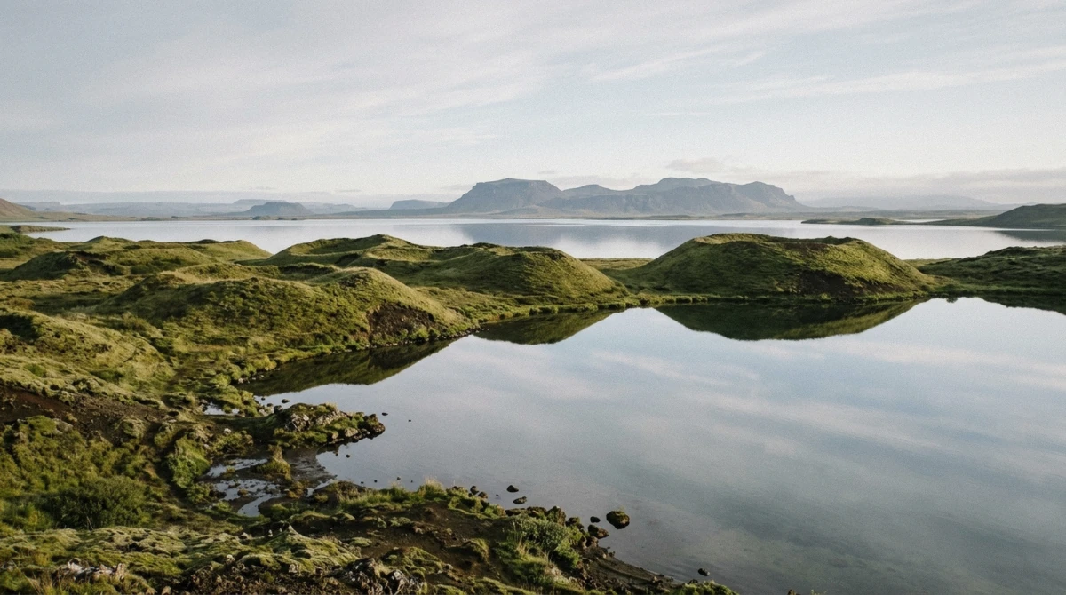
Grassy mounds along the south shore that look like small volcanoes and never erupted anything. Lava ran over the wet ground here about 2,300 years ago, the water flashed to steam and blew rings of ash upward. The result is a pseudo-crater field with a flat loop of 20 to 30 minutes around it.
This is also the best birdwatching on the lake, with 15 duck species breeding in the shallows behind the mounds. It is where the midges are worst in July, and where a head net earns its price.
5. Grjótagjá, the cave you look into
A fissure in the lava with a pool of clear blue water at the bottom, reached through a gap in the rock and a short scramble. Bathing stopped in the 1970s when the Krafla Fires pushed the water to around 60°C, and the landowners still ask visitors to stay out.
Free to visit, free to park, twenty minutes is plenty. It picked up a second life as a filming location, which means a full car park between 11:00 and 15:00 in summer. Larger coaches skip it entirely, so the minibus departures are the ones that stop here.
6. Goðafoss, on the way in
The Skjálfandafljót drops about 12 metres over a curved ledge roughly 30 metres wide, 45 km west of the lake and right beside Route 1. Paths run down both banks, the west side holds the light through the morning, and the name means waterfall of the gods after the lawspeaker who threw his pagan idols in when Iceland turned Christian around the year 1000.
Every guided departure stops here. Forty-five minutes covers both banks at a walk.
7. Krafla and the Víti crater
Nine kilometres north of Hverir, a caldera with 29 recorded eruptions behind it. The Víti crater at the top holds turquoise water and dates from the 1724 eruption that opened the Mývatn Fires. Leirhnjúkur, the lava field beside it, still steams from the Krafla Fires of 1975 to 1984 and gives the most direct look at fresh volcanic ground in the region.
The road up closes under snow into late spring, so this is a summer stop and one that day tours from Akureyri rarely include. A 60 MW geothermal power station runs on the same ground.
8. Lofthellir, the ice cave
About 40 km east, under a lava field reached by a track no rental agreement covers, sits a cave formed roughly 3,500 years ago when molten rock drained out of a lava tube. Inside are ice columns and sheets that hold their shape into summer.
Getting in means crawling through a narrow entrance; getting around means crampons and a helmet. Operators run it from May to October with equipment included. It is the one thing here you cannot do on your own.
9. The geothermal lagoon
On the Jarðbaðshólar ridge 6 km east of Reykjahlíð, the baths that traded for two decades as Mývatn Nature Baths reopened on 9 July 2026 as Earth Lagoon after a full rebuild. Water runs 36 to 40°C, entry starts at 7,900 ISK and doors are open 10:00 to 23:00.
It belongs at the end of the day rather than the middle. Prices, tiers and what the rebuild changed are covered in full separately.
At a Glance
The nine stops, ranked by what they give you
Everything below except the cave and the lagoon is free, and every one has its own car park. Times are what the sight deserves rather than the minimum a bus allows.
| Sight | Where | Best months | How long | Cost |
|---|---|---|---|---|
| Dimmuborgir | East shore, road 848 | All year | 45 to 60 min | Free |
| Hverir | East over the pass, Route 1 | Best in cold air | 30 to 40 min | Free |
| Hverfjall | Behind Dimmuborgir | June to September | 45 to 60 min | Free |
| Skútustaðagígar | South shore | May to September, birds | 20 to 30 min | Free |
| Grjótagjá | North of Hverfjall | All year | 20 min | Free |
| Goðafoss | Route 1, 45 km west | All year | 45 min | Free |
| Krafla and Víti | 16 km north | Late June to September | 60 min | Free |
| Lofthellir | 40 km east | May to October | 3 to 4 h | Guided only |
| Earth Lagoon | Jarðbaðshólar ridge | All year | 90 min | From 7,900 ISK |
How Long Each Stop Needs
Plan the day against this
Times below are what the sight deserves rather than the minimum a bus allows.
| Stop | Time | Cost | Ground | Skip if |
|---|---|---|---|---|
| Dimmuborgir | 45 to 60 min | Free | Packed gravel, steps | Never |
| Hverir | 30 to 40 min | Free | Loose clay, flat | You dislike sulphur |
| Hverfjall | 45 to 60 min | Free | Loose gravel climb | Wind or ice |
| Skútustaðagígar | 20 to 30 min | Free | Flat grass path | July midges are extreme |
| Grjótagjá | 20 min | Free | Short rock scramble | You are unsteady |
| Goðafoss | 45 min | Free | Steps to the bank | Never, it is on the way |
| Krafla and Víti | 60 min | Free | Gravel road, flat rim | Snow, or a tight schedule |
| Lofthellir | 3 to 4 h | Guided only | Crawl, crampons | You have one day |
| Earth Lagoon | 90 min | From 7,900 ISK | Level, indoors | You did Forest Lagoon |
If you only have four hours
Take Goðafoss, Dimmuborgir and Hverir in that order and drop the rest. Those three cover a waterfall, the lava and the geothermal ground, which is the shape of the region in miniature. Add Skútustaðagígar if the light is good, since it costs 20 minutes.
If you have six, that is the classic ring and what the day trips from Akureyri deliver. If you have two days, the second one is Krafla, Lofthellir and either Dettifoss or the whale boats at Húsavík.
How far apart they are
Distances are from Reykjahlíð on the northeast shore, where the fuel, food and beds are. Nothing on the core ring is more than 20 minutes away.
| From Reykjahlíð | Distance | Drive | Road |
|---|---|---|---|
| Hverir | 7 km | 8 min | Route 1 east over the pass |
| Earth Lagoon | 6 km | 7 min | Route 1 east |
| Grjótagjá | 5 km | 6 min | Turn off road 848 |
| Hverfjall | 8 km | 10 min | Road 848 south, then a track |
| Dimmuborgir | 10 km | 12 min | Road 848 south |
| Skútustaðagígar | 17 km | 15 min | Road 848 around the south shore |
| Krafla and Víti | 16 km | 20 min | Road 863 north, closed in winter |
| Goðafoss | 50 km | 35 min | Route 1 west |
| Akureyri | 100 km | 75 min | Route 1 west |
What to Do With the Time You Have
If You have four hours
Goðafoss, Dimmuborgir, Hverir. Nothing else fits properly
If You have a full day
The classic ring: add Skútustaðagígar and Hverfjall
If You have two days
Add Krafla and Víti, plus Lofthellir or a run north to Húsavík
If You are travelling with small children
Dimmuborgir, Skútustaðagígar and the lagoon. Skip the Hverfjall climb
If You want one photograph that explains the place
The Hverfjall rim, 20 minutes up from the west car park
If It is raining sideways
The lagoon and the Dimmuborgir café. The ground stops being fun in wind
Two Things People Try and Should Not
Swimming in the lake
The water averages 2.5 metres deep, sits near freezing for most of the year and lies inside a conservation area of 4,400 km² protected since 1977. Swimming, boating and disturbing the shore are all restricted. The bathing here is at the lagoon.
Getting into Grjótagjá
The pool is on private land and the landowners ask visitors not to enter. Water temperatures spiked to around 60°C during the Krafla Fires and have not settled to anything you would want to sit in. People still climb down, and every guide in the region winces at it.
How to See More in the Time You Have
Reverse the standard order
Every coach runs Goðafoss first thing, the south shore late morning and Dimmuborgir at midday, which is why four buses share one car park at 12:30. Drive it backwards. Dimmuborgir at 09:30 is a different place, Hverir before the coaches has nobody on the boardwalks, and Goðafoss in the afternoon has lost its bus load and kept its light on the west bank.
Three habits that add a stop
None of these costs money.
- Eat in the vehicle rather than at Reykjahlíð, which saves 40 minutes and, in July, saves you eating with midges
- Take the short loop at Dimmuborgir first and decide at the junction whether the Kirkjan arch is worth the extra 25 minutes. Most days it is
- Skip the Hverfjall rim in strong wind rather than doing it badly, and put the hour into Krafla instead between late June and September
Our recommendation
🎯 Reverse the standard order
Almost every bus runs Goðafoss, then the south shore, then Dimmuborgir at midday. Drive it backwards and you will have Dimmuborgir at 09:30 to yourself, Hverir before the coaches, and Goðafoss in the afternoon when its car park has emptied.
The one stop I would not compress is Dimmuborgir. Twenty minutes buys the first loop; the hour buys the arch at the far end and the part where the crowd thins. If you are on a guided day, the comparison of Lake Mývatn departures shows which ones give it 55 minutes or more.
Questions About What to Do
What is there to do at Mývatn lake?
Nine stops: Dimmuborgir lava field, the Hverir geothermal ground, the Hverfjall crater, the Skútustaðagígar pseudo-craters, Grjótagjá cave, Goðafoss waterfall on the way in, the Krafla caldera with the Víti crater, the Lofthellir ice cave and the geothermal lagoon. All but the last two are free.
How much time do you need at Lake Mývatn?
Six hours covers the classic ring including the drive from Akureyri. Four hours covers three stops properly. Two days is what Krafla, Lofthellir and a run to Dettifoss or Húsavík need.
Can you swim in Lake Mývatn?
No. It averages 2.5 m deep, stays cold and sits inside a protected conservation area. Grjótagjá cave is also closed to bathers. The place to get in the water is the geothermal lagoon, where entry starts at 7,900 ISK.
What is the best viewpoint at Lake Mývatn?
The Hverfjall rim, 20 minutes up the gravel path from the western car park, which gives you the lake, the crater islands and the Krafla steam in one turn. For less effort, the ridge above Skútustaðagígar looks north over the pseudo-craters and the water.
Is there anything to do at Mývatn in winter?
Yes, with a shorter list: Goðafoss, the pseudo-craters, Dimmuborgir, Hverfjall, Grjótagjá and Hverir all stay open, and the lagoon runs to 23:00. Krafla and Lofthellir do not. Daylight is the constraint, not access, as the month guide sets out.
Do any of the sights charge an entry fee?
None of the outdoor sights charges anything, and parking is free at all of them. Only the geothermal lagoon and the guided Lofthellir trip cost money. That is unusual in Iceland and worth knowing before someone sells you a ticket.
Which stop is best with kids?
Dimmuborgir, because it works as a maze rather than a viewpoint and it has a café and toilets. Skútustaðagígar is the flattest walk. The Hverfjall climb is loose gravel and a long way down on one side, so it suits older children only.